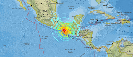
When a massive 7.3 magnitude earthquake strikes just off the coast, the script usually involves widespread destruction and immediate disaster responses. Yet, the powerful tremor that hit near the Mexican town of Puerto Madero on July 17, 2026, managed to break that script. It triggered tsunami alerts and sent waves of panic radiating across Mexico, Guatemala, and El Salvador. Miraculously, the region escaped without catastrophic structural damage or reported deaths.
If you are trying to understand how a massive earthquake could rattle an entire region so violently without leaving a trail of ruins, the answer lies in a mix of geological luck, deep-rooted regional fear, and building designs.
The quake hit at a shallow depth of about 15 kilometers (9 miles), right on the volatile border region between Mexico and Guatemala. The U.S. Geological Survey initially clocked it as a 7.4 magnitude event before stabilizing the data at 7.3. For anyone sitting in an office building in downtown Guatemala City or San Salvador during morning rush hour, those technical differences did not matter. The shaking felt endless.
Understanding the Chiapas Earthquake Shockwaves
The epicenter sat in the Pacific Ocean, roughly 30 miles southwest of Aquiles Serdan along the coast of Chiapas. It wasn't a sudden, isolated snap. A smaller foreshock preceded the main event, giving a brief, deceptive warning before the real energy arrived.
In border cities like Tapachula, Mexico, the experience was a slow, agonizing build. Hospital workers and residents reported that the ground started with a mild tremor, making people think it would just pass. Then it intensified violently, forcing thousands to flee into open courtyards and streets.
The geographical reach of a 7.3 magnitude quake is massive. It caused high-rises to sway as far north as Mexico City, where the sheer distance naturally dampened the punch of the shockwaves. In fact, the capital's famous early-warning siren system stayed silent because the initial energy thresholds weren't crossed—a technical reality that always leaves local residents feeling uneasy when they can clearly feel the floor creaking beneath their feet.
Panic in the Shadow of Past Disasters
You can't look at how people reacted to this event without acknowledging the raw psychological scars hanging over Latin America right now. Just weeks earlier, on June 24, a horrific pair of twin earthquakes tore through Venezuela, killing over 4,800 people and turning entire city blocks into rubble. That disaster was fresh in everyone's minds.
When the Chiapas quake started rocking the upper floors of high-rises, people did not wait around to see if their buildings would hold. In Tuxtla Gutierrez, the state capital of Chiapas, government workers on the upper floors of a 15-story complex described scenes of pure panic as crowds rushed down emergency stairwells, many crying openly.
In Guatemala City, the sheer duration of the shaking sent panicked crowds pouring out onto the asphalt just as the morning commute was getting underway. Local accountant Alexander Valdez recounted fleeing down eight flights of stairs, completely terrified because the motion simply refused to stop. The memory of Venezuela turned a standard evacuation protocol into a desperate race for survival.
The Tsunami Scare That fizzled
Whenever a major seismic event drops into the ocean floor, the ocean responds. The U.S. Tsunami Warning System quickly flagged a potential hazard for any coastline sitting within 186 miles (300 kilometers) of the epicenter. Local agencies like the Meteorological Service of Chiapas warned that waves could swell up to a meter (3.3 feet) above standard tide levels.
The immediate response along the coast was high alert. In the border town of Suchiate, situated right on the river dividing Mexico and Guatemala, local authorities under Mayor Elmer Vázquez Gallardo scrambled to monitor the shoreline for sudden water retreats or surges.
Fortunately, the ocean did not deliver a devastating wall of water. Mexican Secretary of the Navy Raymundo Pedro Morales confirmed that the actual sea level changes were minimal, peaking at less than half a meter. While the structural threat passed quickly, naval officials still issued a strict six-hour ban on beach activities to account for erratic currents and minor surges following the main shock.
What Kept the Region Standing
Why did a 7.3 magnitude quake leave the region largely intact? Part of it is pure geography. Because the epicenter was located offshore, the most violent, tearing motion happened under the sea rather than directly beneath a densely packed urban center.
Mexican President Claudia Sheinbaum and Guatemalan President Bernardo Arevalo both confirmed that emergency checks showed zero fatalities and minimal structural failures. Guatemala's disaster reduction agency, CONRED, noted that the primary physical damage was limited to minor landslides that temporarily blocked western mountain highways. To minimize risk from these unstable hillsides, the Guatemalan Ministry of Education promptly suspended in-person schooling across border departments like San Marcos and Quetzaltenango.
However, seismologists from organizations like the USGS are quick to point out that this was a lucky escape, not a guarantee for the future. The border region relies heavily on a mix of construction styles, including historical adobe brick and mud-walled homes. These traditional structures are incredibly vulnerable to a phenomenon known as soil liquefaction, where solid ground behaves like a liquid under intense, sustained shaking. If the epicenter had shifted just a few dozen miles inland, the story of the Chiapas quake would look entirely different today.
Staying Safe for the Aftershocks
The initial event is over, but the danger shifts to the secondary waves. The region has already logged multiple significant aftershocks ranging between magnitudes 4.9 and 6.0, and they will likely continue for days.
If you are living in or traveling through southern Mexico or western Guatemala right now, you need to remain alert. Take these immediate precautions to protect yourself over the next 48 hours:
- Inspect your immediate surroundings for hairline structural cracks, especially around concrete supports, load-bearing walls, and stairwells.
- Avoid driving through mountainous terrain or cutting through roads with steep embankments, as the ground remains highly unstable and vulnerable to further landslides.
- Keep a basic emergency kit with fresh water, a flashlight, and copies of essential documents near your exit route.
- Follow local civil protection channels for real-time updates on marine safety before heading anywhere near the Pacific coast beaches.
- Memorize the quickest path to an open, outdoor space away from power lines and glass facades, as aftershocks can hit without warning.