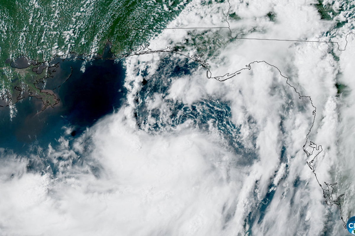
A 40-mile-per-hour tropical storm doesn't sound like a disaster. If you live along the Gulf Coast, you've probably slept through severe summer thunderstorms with stronger wind gusts. So when news broke that Tropical Storm Bertha formed south of the Florida Panhandle on July 20, 2026, plenty of coastal residents brushed it off.
That is a dangerous mistake.
Wind speed gets all the headlines, but water does almost all the killing. Bertha isn't alarming because of its wind velocity. It's dangerous because it isn't moving. National Hurricane Center forecasters caught the storm crawling along at just 2 mph roughly 140 miles south of Panama City. When a tropical system stalls over the Gulf of Mexico, it transforms from a routine weather event into a massive water pump, scooping up oceanic heat and shoving ocean water into bayous, bays, and neighborhoods for days on end.
If you live anywhere between Florida's Big Bend and the middle Texas coast, you need to understand what is actually happening right now, why slow-moving storms wreak total havoc, and what concrete steps you should take today.
Where Tropical Storm Bertha Is Right Now and Where It Is Headed
Tropical Storm Bertha became the second named storm of the 2026 Atlantic hurricane season after organizing in the eastern Gulf. As of July 21, 2026, the storm sits about 125 miles south of Panama City, Florida, and 200 miles southeast of Mobile, Alabama, packing sustained winds of 50 mph with stronger localized gusts.
The National Hurricane Center issued a Tropical Storm Warning stretching from the Alabama-Florida state line west through southeastern Louisiana. Simultaneously, a Storm Surge Watch spans from the mouth of the Mississippi River all the way to the Alabama-Florida border.
Here are the critical geographic details you need to track:
- Florida Panhandle and Big Bend: Expect 3 to 5 inches of rain, localized tornadoes, high surf, and dangerous rip currents. Emergency officials in Escambia County have already set up sandbag distribution sites to stem immediate neighborhood flooding.
- Alabama Beaches: Red flags line the coast in places like Orange Beach. Double red flags mean the water is completely closed to swimming due to extreme surf and life-threatening rip currents.
- Louisiana Coastal Parishes: Low-lying communities near the Mississippi River delta face up to 4 feet of storm surge inundation. Combined with expected rainfall totals of 3 to 5 inches, lowland drainage systems will be severely tested.
- Texas Coast: While Bertha is currently hanging near the Florida-Alabama border, steering currents are expected to push the lingering moisture westward toward central and middle Texas through the end of the week.
Meanwhile, over in the eastern Pacific, Hurricane Fausto strengthened about 745 miles southwest of Baja California. Fausto boasts 75 mph winds and is pushing west-northwest. It poses no direct threat to land, though it will generate rough seas and dangerous rip currents along the Mexican coast. Bertha is the primary concern for anyone residing along the US Gulf Coast right now.
The Hidden Danger of the Slow Crawl
People look at storm categories and make quick calculations. A Category 3 hurricane gets everyone rushing to board up windows. A simple tropical storm with 40 or 50 mph winds barely registers on people's radars.
That line of thinking leaves homeowners completely unprepared for water damage.
When a storm moves at 15 or 20 mph, it hits an area, dumps a couple of inches of rain, blows down some weak tree limbs, and leaves. The water drains quickly. Life gets back to normal within 24 hours.
When a storm creeps along at 2 mph or stands virtually stationary like Bertha, three brutal phenomena happen at once:
Continuous Onshore Wind Pushes Water Up Inlets
A persistent wind blowing from the south or southwest over two or three days acts like a massive bulldozer against the ocean. It constantly pushes water into shallow bays, rivers, and coastal estuaries. Because the high tide cycles keep coming every 12 hours, the ocean water pushed inland has nowhere to retreat. The water piles up layer upon layer. That is how a weak storm produces 3 to 4 feet of localized storm surge in low-lying marshlands and coastal roads.
Ground Saturation Triggers Massive Flash Floods
Coastal soil acts like a sponge, but even a sponge has limits. The first 2 inches of rain soak into the ground without much issue. By the second day, when another 3 to 5 inches drop on saturated dirt, 100 percent of that new rainfall turns into immediate runoff. Ditches fill up, storm drains back up into street intersections, and small creeks quickly overflow their banks.
Tropical Moisture Bands Cause Persistent Heavy Downpours
Slow-moving systems feed continuously off warm ocean water. Training bands—lines of heavy thunderstorms that repeatedly pass over the exact same spot—can drop 2 to 3 inches of rain per hour in localized areas. Even if official forecasts call for widespread totals of 3 to 5 inches, isolated pockets often catch double or triple that amount.
Common Emergency Prep Mistakes People Make During Weak Storms
Having covered dozens of coastal storms, I see residents fall into the exact same traps every single year. A tropical storm warning is not a vacation day—it's a window of time to protect your family and property.
Here are the most frequent mistakes made during slow-moving tropical storms:
Relying Entirely on Sandbags to Stop Water
Sandbags are helpful for diverting trickle flow away from low garage doors, but they are far from waterproof. Standard burlap or plastic sandbags let water seep through gaps. If you sit sandbags directly against a doorway without a plastic membrane behind them, water will find its way into your home.
If you are filling sandbags in places like Escambia County right now, layer heavy-duty 6-mil plastic sheeting against your doors first, then stack the sandbags tightly in an overlapping brick pattern against the plastic.
Ignoring Beach Warning Flags
It seems obvious, but every storm brings individuals who want to check out the heavy surf or try body surfing in the storm swells. Red flags in places like Orange Beach, Alabama, mean the water is lethal. Rip currents generated by a tropical system hundreds of miles away can easily pull an experienced swimmer hundreds of yards out to sea in less than 60 seconds. Stay out of the water entirely until local officials give an official clear signal.
Parking Vehicles in Driveways Near Drainage Ditches
You might think your driveway is safe because your house has never flooded inside. However, standard street drainage channels can overflow rapidly during intense rain bands. Parking a car in a low driveway or on the street right next to a storm drain leaves your transmission and electronics vulnerable to rising water. Always park on higher ground, back your car into a elevated garage, or park on ramps if you reside in a low zone.
Waiting Until Power Outages Strike to Charge Devices
Slow-moving storms frequently knock out power due to saturated soil loosening tree roots. Moderate wind gusts of 40 to 50 mph are more than enough to topple heavy pine branches onto power lines when the ground is soaked through. Fill your vehicle fuel tanks, top off all portable power banks, and freeze water containers today.
Understanding the 2026 Atlantic Hurricane Season Pattern
Bertha's arrival marks a distinct shift in the 2026 Atlantic hurricane season. Early season forecasts pointed to a relatively quiet start due to broader climate cycles like El Niño, but tropical weather can shift rapidly once sea surface temperatures cross critical thresholds.
The Gulf of Mexico is currently running unusually warm. Warm water acts as aviation fuel for tropical weather. Even when a storm contends with dry air pockets or moderate wind shear—which prevents Bertha from rapidly intensifying into a major hurricane—the ocean heat fuels massive amounts of atmospheric moisture. That moisture gets dumped across coastal states as Bertha drifts across the region.
This is why tracking the path matters far less than tracking the weather impacts. A storm does not need to achieve hurricane status or make a crisp landfall to cause millions of dollars in flood damage.
Actionable Steps to Take Right Now
If you live in Florida, Alabama, Mississippi, Louisiana, or eastern Texas, take these exact actions over the next 12 to 24 hours:
- Clear Household Gulleys and Gutters: Pull leaves, twigs, and debris out of roof gutters and yard drains. If water cannot flow away from your foundation, it will collect around your home's perimeter.
- Secure Outdoor Furniture and Trash Cans: Tropical storm wind gusts of 40 to 50 mph can pick up patio chairs, trash lids, and yard decorations, turning them into flying projectiles. Move everything inside your garage or shed.
- Elevate Important Belongings in Storage: If your garage, shed, or ground-floor rooms are prone to minor seepage, move electronics, power tools, and cardboard storage boxes up onto tables or shelves.
- Prepare a 72-Hour Supply Kit: Ensure you have clean drinking water (one gallon per person per day), non-perishable food, flashlights, extra batteries, a manual can opener, and necessary prescription medications.
- Turn off Automatic Lawn Sprinklers: It sounds minor, but adding extra water to saturated ground compounds local drainage issues.
- Set up Local Emergency Notifications: Enable Wireless Emergency Alerts on your smartphone and monitor your local National Weather Service office broadcast for real-time flash flood warnings and tornado warnings.
Pay attention to your immediate surroundings, stay off flooded roadways, and don't underestimate what a slow-moving storm can do. Water moves fast, rises quietly, and takes very little time to turn a minor inconvenience into a serious emergency.